750,000+
Emission events mapped
9 of 10
Top U.S. natural gas producers trust Bridger
30+
Patents and patents pending
90%
Detection probability for >1 kg/hr emissions
Trusted by leading energy professionals worldwide.


You’re Managing a Lot. Bridger Helps You See It Clearly.
Methane monitoring means something different for everyone in the energy chain.
-
If you’re in upstream, you’re balancing detection with operational efficiency.
-
In midstream, it’s about maintaining safety and meeting regulatory demands.
-
For utilities, reliability and public trust are always on the line.
-
And for executives, it’s all about demonstrating ESG performance and sustaining investor confidence.
No matter where you sit, success depends on clear, actionable insight - knowing exactly where emissions are coming from, how much is being released, and what to address first.
That’s where Bridger Data comes in. Our world-class patented aerial laser system gives you precise, quantified data so you can act decisively.
- Field crews know exactly where to go.
- Compliance teams can report with confidence.
- Executives can stand behind every number.

You’re Managing a Lot.
Bridger Helps You See It Clearly.
Methane monitoring means something different for everyone in the energy chain.
Upstream
You’re balancing detection with operational efficiency.
Midstream
It’s about maintaining safety and meeting regulatory demands.
Utilities
Reliability and public trust are always on the line.
Executives
Demonstrating ESG performance and sustaining investor confidence.
No matter where you sit, success depends on clear, actionable insight - knowing where emissions are coming from, how much is being released, and what to address first.
That’s where Bridger Data comes in. Our world-class patented aerial laser system gives you precise, quantified data so you can act decisively.
- Field crews know where to go.
- Compliance teams can report with confidence.
- Executives can stand behind every number.
With Bridger, you get more than data; you gain the clarity and confidence to lead in responsible energy production.
-1.png?width=2151&height=317&name=Trailblazer_USA%20and%20Australia_Click%20Here%20Web%20Banner%20(1)-1.png "Trailblazer_USA and Australia_Click Here Web Banner (1)-1")
.png?width=450&height=450&name=Untitled%20design%20(39).png)
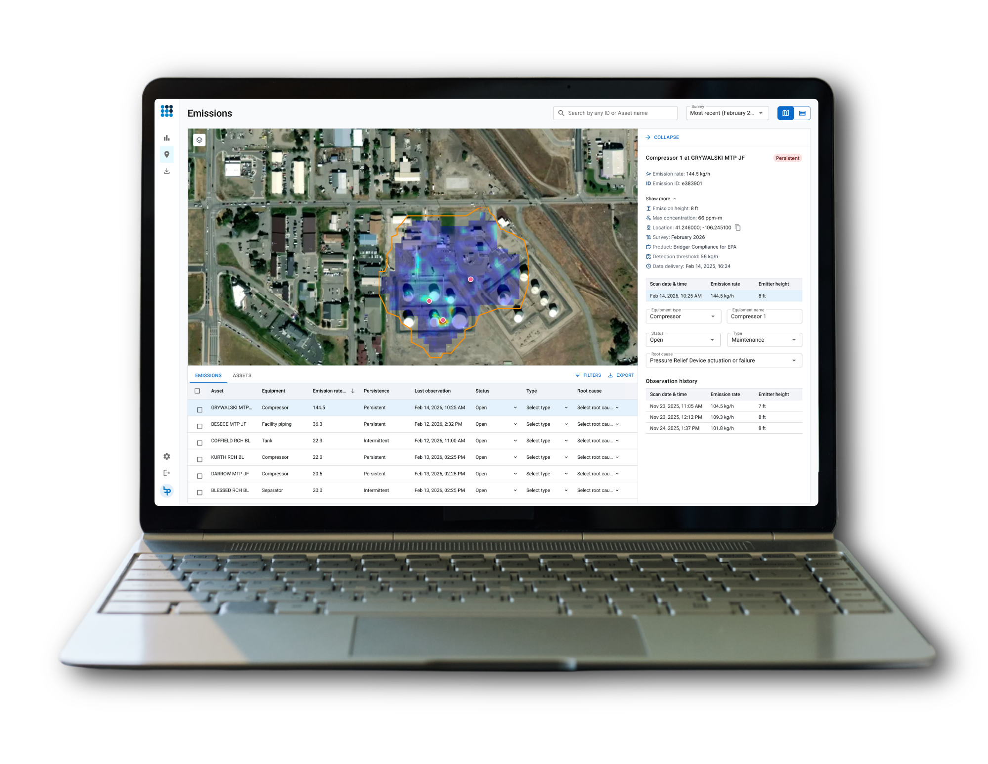
INTRODUCING BRIDGER COMMAND
A More Intuitive Way to Engage with Your Emissions.
Bridger Command™ is an interactive emissions management platform designed to streamline the use of methane emissions data and analytics across oil and gas teams. Best-in-class data just got better.
One platform. One trusted view. Faster, more confident action.
Get a Demo
All Locations
We'll meet you where you're at, with growing capabilities and trusted partners across the globe.
All Assets
From offshore platforms to LNG facilities, to wells, compressors, and more.
All Seasons
Trusted emissions data, from snowy winter days to the heat of the summer.

Emissions Data, Made Actionable
Audit-ready. Regulator-trusted. Usable by every team.
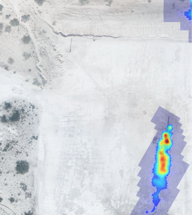
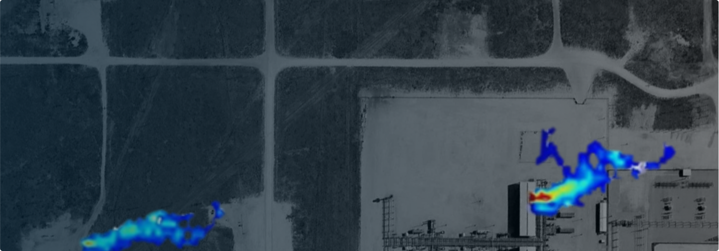
Every surgery results in a geo-tagged plume map with quantified emissions rates. This level of detail gives operators the confidence to act quickly, compliance teams the documentation they need for regulators, executives a credible story for investors, and ESG leaders a foundation for transparent reporting.
Every emission mapped, quantified, and geo-tagged for action.
About Bridger
Bridger Photonics started in Bozeman, Montana with a vision to make methane detection simpler, more accurate, and more actionable for the energy industry.
Today, Bridger combines 30+ patents, EPA recognition, and global adoption with the same spirit of integrity and innovation that defined our founding. From Bozeman’s unique hub of photonics expertise, our team is helping operators, executives, and compliance leaders worldwide reduce emissions with confidence.


